Monday, September 30, 2019

GAP / C&O Adventure: Day 7: Devil's Alley to Ft Frederick

There are so many good things about today's ride. Let's start with the fact that the paved Western Maryland rail trail runs parallel to the C&O for 25 miles and there are geocaches along the way! Plus, we can now say that we have ridden the Wester Marilyn Rail Trail!


We stopped in Hancock at the bicycle shop pick up a spare tube and ice cream for T. We were really impressed with the prices, I am sure there are bicycle shops that take advantage. After making a run to the Save-A-Lot for more Gatorade and some fresh fruit, we headed for
Ft Frederick.

We arrived around 1:30 and found interpreters in costume at the old fort. The place is absolutely stunning, both from the perspective of the natural surroundings as well as the historical story of those being told. We spent a couple hours looking around talking with the interpreters, and just taking interview before making our way to the visitor center to get our campground pass for the evening. Fort Frederick was definitely a highlight. Note that the costumed interpreters are generally there on the weekends; you might call ahead to see what's happening when you are passing through.

Fort Fredrick barracks.
Road from the trail up to the fort.
The best part of the night though, was after we had pitched our tent and eaten dinner. Up near the fort, was an outdoor shower that was available for people to rinse off after being in the Big Pool (canal pond). The signs clearly indicated one must wear a bathing suit while rinsing off. We were thrilled to be there in our "bathing suits" washing our hair and scrubbing off all of the salt, sweat, grease, dirt, bugs, etc from our bodies. Glorious!

Rinse off stations. 
Camping permit hangtag for my bike.


Campground: Ft Fredrick State Park; $22.25

Wildlife: lots of deer!

Total mileage for the day: 36.6


Tip: The outdoor shower...and the water is warm!


Sunday, September 29, 2019

GAP / C&O Adventure: Day 6: Cumberland to Devil's Alley Hiker Biker Camp (MP 144)

Woke up this morning to some great tasting coffee and homemade bread at our Airbnb. T went out to get our bikes from the garage and found that I had a flat tire. So we changed the tire, got some groceries, had to detour around a train that was stopped on the tracks in order to get back to the trail. By the time we finally got going it was after 11:00am.

It was a hot ride today, somewhere in the high 80s. Fortunately the trees provided a nice amount of shade as we rode the trail. Cyclists on the GAP had warned us about how bumpy the trail would be. However, having ridden the Weiser River trail in Idaho, we thought the C&O was pretty decent.


The canal and locks are very interesting. We stopped to look at various structures along the way. At one point after saying hello to a couple of other cyclists, T noticed that she had a flat tire. No worries, I had just learned how to change a flat that very morning! In about 5 minutes we were ready to go.

Turtle watching.
The Paw Paw Tunnel was a little disconcerting. In this tunnel, the canal was still intact and you were on the path up above the water. Personally, I couldn't get out of there fast enough.

Paw Paw Tunnel
Bring your light!

We got to where we thought we would camp, only to find a couple was already there and the water pump was not working. They didn't seem too friendly so we continued on to the Devil's Alley at Milepost 144. There was already somebody camping there, but there was room for us.

It was almost six o'clock and it was VERY hot and muggy. We cleaned up in the Potomac River and filtered some drinking water (the water pump was treated with iodine, and that was all you could smell, so we opted for river water), and made our dinner.

It was a long hot night.

View from our campsite the next morning.
Campground: Devil's Alley Hiker/Biker Camp at Milepost 144 (free)

Total mileage for the day: 44.5

Terrain / Trail Conditions:
lightly graveled with some roots and rocks.


Tip: A lot of the camps along the trail were pretty deep in the trees. But this camp was a little more open and had a nice view of the river.


Saturday, September 28, 2019

GAP / C&O Adventure: Day 5: Meyersdale to Cumberland

We went through the Big Savage tunnel today, it even had lights! 

The ride up to the Eastern Continental divide was a gradual slope. Once we arrived we celebrated with all of the rest of the bicyclist who were there, took lots of photos, and enjoyed the murals. From there it was all downhill to Cumberland!

Eastern Continental Divide
One of the most interesting historic sites along the way was when we got to cross the Mason Dixon line at the Pennsylvania/Maryland border.

Mason-Dixon. Take the time to read the historical info.
Where am I?
We stopped in Frostburg, and took the short bicycle trail up to get lunch with the ladies from Kentucky. The switchback trail was a pretty easy ride and had some amazing artwork to look at along the way. Our little lunch stand was across from the train that people take between Cumberland and Frostburg for sightseeing or to get their bicycle up to the top of the hill so they can ride back down to Cumberland.

We rolled into Cumberland around 4:00, checked out sites downtown, said goodbye to our new friends, and headed for our Airbnb (our hosts were great and their place was immaculate). Only downside is that it was up such a steep hill that we actually had to walk our bikes part of the way. Enjoyed an amazing shower, did some laundry, and then walked into town for dinner at The Manhattan Social.

All and all, it was a great day.

Total mileage for the day: 34.4


Tip: I'm sure a lot of people look at the elevation maps and are a little concerned about writing their bicycle to the eastern continental divide. The segment from Meyersdale to the divide was a nice ride and less steep than what we had already ridden.


Friday, September 27, 2019

GAP / C&O Adventure: Day 4: Confluence to Meyersdale


It was a beautiful fall day and one of the things that was a little bit different was that we went through a bit of farmland. We also went over the Salisbury Viaduct which is 1,908' long and 101' high and goes right over the Mason-Dixon highway. This was probably the single most amazing sight on the GAP.

Farm with a friendly farmer.
Salisbury Viaduct
We pulled into the campground around 3:00 or 3:30 and called the phone number that was listed. A really nice lady named Susie is in charge of collecting fees. She has thought of everything! There are boxes of games, a bucket of rags to clean your bike, clothesline with clothespins, and even a can opener! And, would you believe, Wi-Fi? Yes, this place has at all.

One of the things that we have come to realize along the trail is that the most popular store we have found is the Dollar General. No fresh fruits or vegetables, but generally there is milk, Gatorade, lots of junk food, and a variety of canned vegetables. We grabbed a can of tomato, corn and okra to toss in with our freeze dried chicken and chickpea pasta and made our way back to camp.

We were fortunate to be able to squeeze our small tent up on the stage next to a giant tent that had four other people staying in it. We also met two really nice ladies from Kentucky who were riding the trail. We exchanged stories and the next day ended up leapfrogging with them.

Can you see our tiny tent in the far left corner?
Get there early if you want the stage!
New friends from Kentucky
Campground: Maple Festival Park, $15

Total mileage for the day: 33.9


Tip: Get there a little early, so that you can camp up on the stage. There are showers and flush toilets, but they are a number of steps away from the camping area. If you do camp on the grass, you might want to look up and identify where the street lights are located.


Thursday, September 26, 2019

GAP / C&O Adventure: Day 3: Connellsville to Confluence

Had a pretty good night in the Adirondack hut in Connellsville, but there certainly were a number of trains to be heard! After we left camp, we went up to the Connellsville Canteen which also serves as a museum. There was a fantastic diorama of the railroad yards and the area. At one point there were 48 engines that rotated on a circular platform so that the trans could go in and out efficiently. thank goodness that there are no longer that many trains in the area!

Connellsville — The Adirondack huts are off to the right of the arch.
Easy riding.
A gorgeous September day.
Today's big stop was Ohiopyle State Park visitor center. Of course as we were looking at the scenery, I hit a tiny little concrete sidewalk at one mile per hour and down I went. Fortunately I had my helmet on....one very sore knee and some short lived dizziness, blurred vision, and hearing loss...I was concerned that the trip was over. Some fluids, rest, and Advil, and we finished looking around town while our laundry was drying.

We camped in Confluence at the Yough Dam Outflow Campground. After an extremely hot day, the showers were amazing, and the sound of the water being released from the dam made for a pleasant evening. The train was pretty far away, so we really didn't hear that at all.

Our campsite looking over to the biker camping area.
Campground views
We also met a guy named Tim from Pittsburgh who is riding the trail. He was super nice and the next morning we ended up having breakfast with him at Mitch's Fuel and Food. The ladies in the cafe were awesome — they even had gluten free bread!

Total mileage for the day: 31.2 miles

Historic Sites: Connellsville Canteen, which served hundreds of thousands of service men during World War II.

Terrain / Trail Conditions: Excellent.

Campground: Yough Dam Outflow Campground. There is a bicycle section in the campground, which runs $8 per person. We ended up getting a regular tent site because we did not want to camp on the grass (trying to minimize condensation).


Tip: Definitely stay at the Outflow Campground. The price is right in the amenities are excellent.


Wednesday, September 25, 2019

GAP / C&O Adventure: Day 2: Dravo to Connellsville

Perfect weather and a perfect ride! Met Ron, an older gentleman who had camped in the next shelter over...I suspect lives on the trail during the summer. He gave us the heads up about places to stay and so we headed for the trailside Adirondack huts in Collinsville, formally known as "Stewart's Crossing Campground & Adirondack Shelters."

This must be a regional thing — live bait in a vending machine.
The trail was exceptionally smooth and we had a wonderful 35.5 mile ride. One of the highlights was the little patio area with a couple of refrigerators right along the trail! There was an assortment of cold drinks, fruit, ice cream, and even a few boiled eggs. So T grabbed a hard boiled egg for 25 cents and off we went.

Beautiful fall day with great trail conditions.
Hard boiled eggs for 25 cents!
Just past the egg stop, we noticed what appeared to be artwork in the old coal mine ruins along the trail and a few hundred feet beyond we found Sager Mosaics. We stopped in the studio and spoke with the artist. If you call ahead, you can schedule a tour of the Ruins Project.

Other than old coal mine ruins and a few houses along the way, most of what we saw was the Youghiogheny River. We rode upriver and will continue to do so until we reach the Eastern Continental Divide somewhere near Frostburg, Maryland.

Total mileage for the day: 35.6 miles

Campground: Stewart's Crossing Campground & Adirondack Shelters (free)


Tip: The Adirondacks are right behind Martin's grocery store! They have a fantastic chicken salad sandwich on a croissant and really nice bathrooms.


Tuesday, September 24, 2019

GAP / C&O Adventure: Day 1: Point Park to Dravo

We got onto the trail around 9:45am and were surprised by the number of people on the trail on a Monday morning. I'd estimate that we saw at least 30-40 people.

Point Park in Downtown Pittsburgh — Ready to Roll!

One of the first things we saw was the updated mileage sign near the Hot Metal Bridge, which said 350miles to Washington, D.C.

Points of interest today included the Dravo Cemetery/camping area and the cute little visitor center in Boston. Believe it or not, we are the first to register at the Boston visitor center from Oregon this year!

Boston visitor center with the friendly host, Ron(?)
With a start time much earlier than expected and we were a little concerned that we would arrive at Dravo (our first overnight destination) much too early to stop. Pulling in around 2pm, we weighed our options: stay here at this amazing campsite, set up camp in one of the two Adirondack huts (the other one was occupied), clean up and have an early dinner OR ride another ten miles or so, risk not having a shelter, and get stuck riding in the rain. We opted to stay. And glad we did, as around 5:30, there was a torrential downpour...and we were dry and happy!

Dravo Adirondack; notice the chairs around the fire pit.
Bike rack as wood transport.
Total mileage for the day: 28 miles.

Terrain / Trail Conditions: A good 17 miles out of Pittsburgh was paved...although I have to say that I prefer the crushed limestone...potholes and cracked pavement in Pittsburgh was something else!

Campground: Dravo (free)

Wildlife: Squirrels, a fawn, ground hog, cardinals.


Tip: Stay at Dravo. According to the guy camped with us (who rides up and down the trail all the time), this is the best campground the entire way.


Monday, September 23, 2019

GAP / C&O Adventure: Fun in Pittsburgh


What a great couple of days we've had in Pittsburgh!

I think we were both surprised at how bike friendly this city is. We cycled everywhere we needed to go with the exception of taking a bus from the airport down to our hotel right near the Point.

Some of the highlights include:

  • Taking the incline up Mount Washington only to find Music on the Mount!
  • Riding down on the Duquesne Incline — be sure to stop in the museum...for 25 cents, you get to see the inner workings of incline.
  • Riding over multiple bridges.
  • Touring the Fort Pitt Museum — a good orientation to the areas you will be riding through, especially if you are also riding the C&O.
  • A very brief stop at the Warhol Museum on "free Sunday" — think 6 floors in 10 minutes!
  • Condado Tacos — loved the menu and super Celiac friendly!
  • Randyland — his message of positivity is not to be missed.
Beautiful night time view from the Incline.
Love the bike friendly bridges!
Randyland
Tip: We loved, loved, loved the location of the Wyndham Hotel. BUT, the cleanliness factor was something else. If you do stay, check your room first and if it's not clean, have them give you a new room. Sigh.


Sunday, July 28, 2019

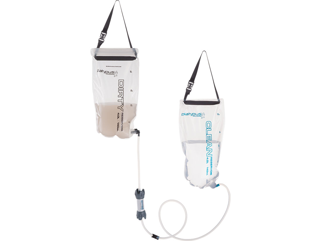
Water Filtration: GravityWorks 4.0L

When we bike or backpack, the last thing we want to do is to manually filter our water. We also believe that it is important that, as a group, we are not doubling up on various items.

About three years ago, we had done quite a bit of research on water filtration systems. We liked the gravity fed system (less work, more relaxation time) and decided to go with the Platypus GravityWorks 4.0L Water Filter System for use on our backpacking trip.

On that first trip, our system supported five of us and on some days, we were filtering between 20-40 liters of water. We have filtered all types of water: stream, lake, pond, and even brackish, all with the same result. Occasionally, things slow down a bit, but if we just follow the directions and back flow it, everything works fine.

We have used this system on each subsequent trip, following the manufacturer's purification instructions when we return home to ensure that it was clean and ready for storage.

Five stars all the way on this device!
Image from the Manufacturer


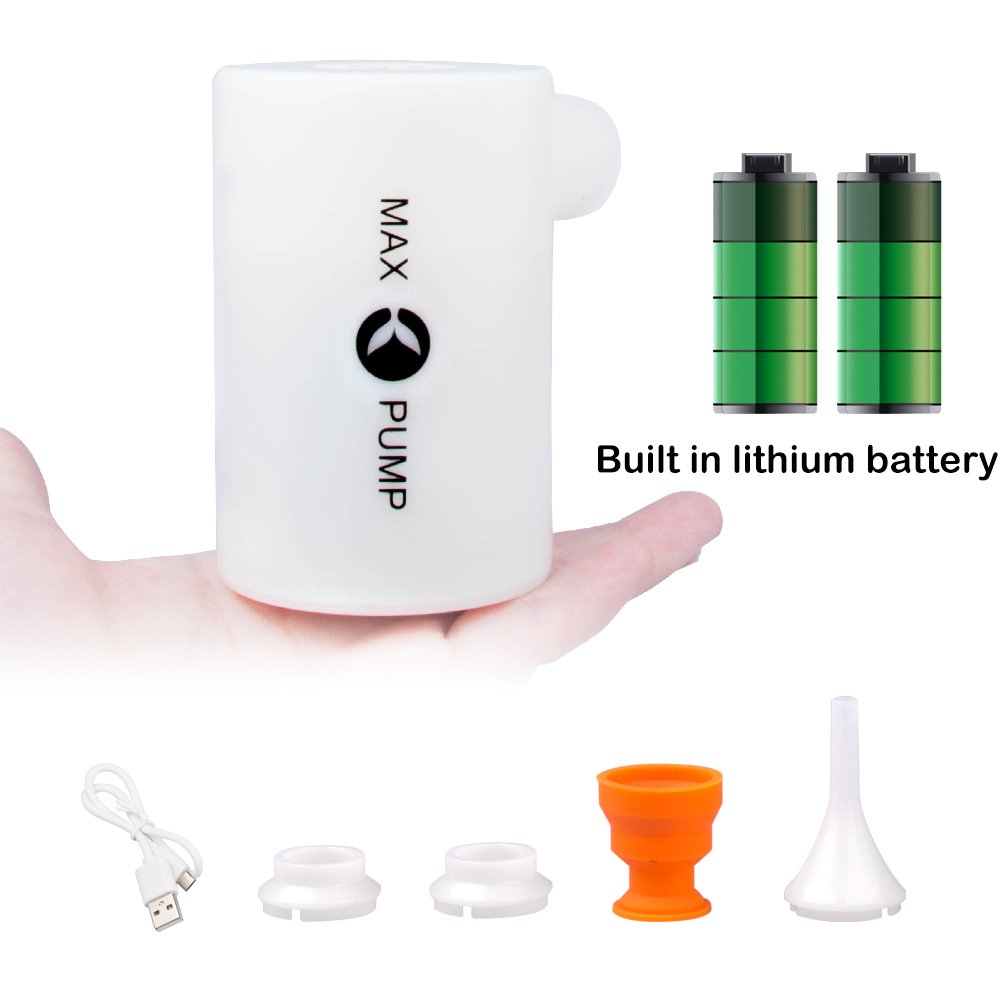
X-Lounger Portable Air Pump

My oh my. The X-Lounger Portable Air Pump is our newest luxury item to go on our adventures.

Remember, we are ultra lightweight backpackers...for example, our packs, with water weighed in at 21.5 lbs for a 7-day trip. So, when we opt for a "luxury item," it had better be worth its weight.

Manufacturer Claims

  • Weighs 4.7 ounces
  • Inflates your air mattress more than 20 times on a single charge.

What We Found

  • This little pump weighs in at 5.5 ounces, and that's without the attachments. 
  • We took the pump on a 60 mile backpacking trip as a luxury item...we pumped up 4 air mattresses 6 times each (24 uses) and there was no change in output over time.
Five stars all the way on this device!

Image from Amazon

2019 NUT Day 7: Mott Segment


Today was the last day of our adventure. We had a leisurely breakfast and took our time packing up camp. We made our way back to the Mott trailhead to do the last segment of the trail.

As we got started, we were pretty happy to see the "easy" sign. It had been a lot of up and down hiking over the past six days, and this was a nice reprieve. We saw eight other people out on the trail and a few fly fishermen in the river. Once we hit about three miles, we didn't see anyone else on the trail.

We stopped at about three and a half miles or so for lunch on a large rock outcropping that overlooked the river and then headed back along the trail.

All in all, it had been a good trip.


Total mileage for the day: 5.8 miles

Wildlife: Nothing on the trail.

Trail conditions: Hot; mainly shady areas along the river. 

Terrain:  Flat; rocky.

Scenery: River views from river or just above river level.

Surprises: We saw people on the trail!

2019 NUT Preparations: What We Did Right & Wrong

Having discovered the trail purely by accident, and seeing how nicely the map was all laid out for us, we thought, "wow, this will be a walk in the woods." That would be mistake #1.

On previous trips we have a routine:
1. Read a LOT about about other people's experiences.
2. Search for and download KML files from other hikers.
3. Save KML files and maps for use in Gaia GPS app.
4. Call and talk to knowledgeable forest service personnel.
5. Order a paper map of the trail.
6. Cross reference all information.
7. Follow up with forest service before leaving.

On this trip, we had done some research, but weren't terribly worried about anything because we were going to be on a nice trail outlined in the "brochure" from the USFS.

1. There was not much first hand information about hiking this trail. I did find this article. The article was about the hike taken by a group of people who had similar skills to us and their stay along Medicine Creek. We made a special note about camping out along Medicine Creek as they had, but what we found after getting there, were lots and lots of downed trees and no perceivable place to camp. More on that in the Deer Leap post.

2. No backpackers had uploaded files to the typical trail sites. I didn't even think about trail running sites. That would have been helpful...especially for the Dread and Terror section because the mileage in the "brochure" was not especially accurate.

3. Like I said, I hadn't found any KML files...

4. Therese called and spoke to several people during the month before the trip at the USFS. The best information was from the folks at the Glide Ranger Station. The fellow there had actually hiked the trail and could speak to her questions.

During a previous call, she had requested a copy of the trail map (the "brochure" as we referred to it), which someone hesitantly mailed to her ("it's online...can't you look at it there?"). The folks at the other ranger stations, listed on the "brochure," were not specifically helpful, as they had no personal knowledge of the trail.

Basically the basis for our entire trip were these two resources: the North Umpqua Trail website and the associated brochure (which is much easier to read on paper).

5. Well, we didn't order a paper map. After all, we had the "brochure."

6. Not much to cross reference...

7. One of the other USFS folks that Therese spoke to, had mentioned that there were two sections closed due to slides. This was pretty important information to have and we did follow up the day before we left so that we had the most current information.

In hindsight, I wish that we would have:
  • Asked specifically about camping options along the trail rather than relying on the "brochure" which made several sites appear accessible to hikers, but in reality they were not; and
  • Brought along a USFS NUT map with notations regarding potential camping locations and potable water information.

2019 NUT: Backpacking the North Umpqua Trail

Last winter, we ran across one of the trailheads of the North Umpqua Trail (NUT), complete with a map of the entire trail. Our eyes about popped out of our heads when we saw that we had an easily accessible 80 mile trail within a couple of hours of home. We looked at each other and knew at that moment that we would be backpacking the NUT during the summer of 2019.

The following posts outline our 7 days on the trail in late July 2019, including where we stayed, our mileage, and observations along the way. Fortunately for us, I think we outnumbered the mosquitoes and we rarely saw any wildlife, other than a few small snakes and several dead birds. We also saw variety of wildflowers over the course of the trail.

We started at the Kelsay Valley trailhead and ended at the Wright trailhead (the Tioga segment was closed, due to slides and an unsafe trail). Total ground covered: exactly 60 miles.

The posts are broken up so that they cover the segments outlined in the trail "brochure," although our camps were generally mid-segment.

Happy trails!

NUT Preparations: What We Did Right & Wrong

Gear


Day 1: Lemolo Segment - best waterfalls


Day 3: Hot Springs Segment - shortest trek


Day 5: Jessie Wright & Marsters Segments - most populated (Wright)

Day 6: Calf & Panther Segments - best forest scenery (Panther)