Sunday, July 28, 2019

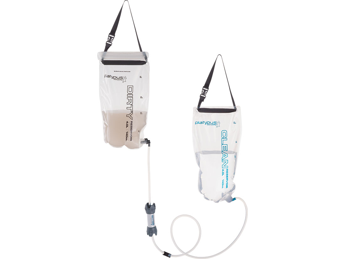
Water Filtration: GravityWorks 4.0L

When we bike or backpack, the last thing we want to do is to manually filter our water. We also believe that it is important that, as a group, we are not doubling up on various items.

About three years ago, we had done quite a bit of research on water filtration systems. We liked the gravity fed system (less work, more relaxation time) and decided to go with the Platypus GravityWorks 4.0L Water Filter System for use on our backpacking trip.

On that first trip, our system supported five of us and on some days, we were filtering between 20-40 liters of water. We have filtered all types of water: stream, lake, pond, and even brackish, all with the same result. Occasionally, things slow down a bit, but if we just follow the directions and back flow it, everything works fine.

We have used this system on each subsequent trip, following the manufacturer's purification instructions when we return home to ensure that it was clean and ready for storage.

Five stars all the way on this device!
Image from the Manufacturer


X-Lounger Portable Air Pump

My oh my. The X-Lounger Portable Air Pump is our newest luxury item to go on our adventures.

Remember, we are ultra lightweight backpackers...for example, our packs, with water weighed in at 21.5 lbs for a 7-day trip. So, when we opt for a "luxury item," it had better be worth its weight.

Manufacturer Claims

  • Weighs 4.7 ounces
  • Inflates your air mattress more than 20 times on a single charge.

What We Found

  • This little pump weighs in at 5.5 ounces, and that's without the attachments. 
  • We took the pump on a 60 mile backpacking trip as a luxury item...we pumped up 4 air mattresses 6 times each (24 uses) and there was no change in output over time.
Five stars all the way on this device!

Image from Amazon

Saturday, July 27, 2019

2019 NUT Day 7: Mott Segment


Today was the last day of our adventure. We had a leisurely breakfast and took our time packing up camp. We made our way back to the Mott trailhead to do the last segment of the trail.

As we got started, we were pretty happy to see the "easy" sign. It had been a lot of up and down hiking over the past six days, and this was a nice reprieve. We saw eight other people out on the trail and a few fly fishermen in the river. Once we hit about three miles, we didn't see anyone else on the trail.

We stopped at about three and a half miles or so for lunch on a large rock outcropping that overlooked the river and then headed back along the trail.

All in all, it had been a good trip.


Total mileage for the day: 5.8 miles

Wildlife: Nothing on the trail.

Trail conditions: Hot; mainly shady areas along the river. 

Terrain:  Flat; rocky.

Scenery: River views from river or just above river level.

Surprises: We saw people on the trail!

2019 NUT Preparations: What We Did Right & Wrong

Having discovered the trail purely by accident, and seeing how nicely the map was all laid out for us, we thought, "wow, this will be a walk in the woods." That would be mistake #1.

On previous trips we have a routine:
1. Read a LOT about about other people's experiences.
2. Search for and download KML files from other hikers.
3. Save KML files and maps for use in Gaia GPS app.
4. Call and talk to knowledgeable forest service personnel.
5. Order a paper map of the trail.
6. Cross reference all information.
7. Follow up with forest service before leaving.

On this trip, we had done some research, but weren't terribly worried about anything because we were going to be on a nice trail outlined in the "brochure" from the USFS.

1. There was not much first hand information about hiking this trail. I did find this article. The article was about the hike taken by a group of people who had similar skills to us and their stay along Medicine Creek. We made a special note about camping out along Medicine Creek as they had, but what we found after getting there, were lots and lots of downed trees and no perceivable place to camp. More on that in the Deer Leap post.

2. No backpackers had uploaded files to the typical trail sites. I didn't even think about trail running sites. That would have been helpful...especially for the Dread and Terror section because the mileage in the "brochure" was not especially accurate.

3. Like I said, I hadn't found any KML files...

4. Therese called and spoke to several people during the month before the trip at the USFS. The best information was from the folks at the Glide Ranger Station. The fellow there had actually hiked the trail and could speak to her questions.

During a previous call, she had requested a copy of the trail map (the "brochure" as we referred to it), which someone hesitantly mailed to her ("it's online...can't you look at it there?"). The folks at the other ranger stations, listed on the "brochure," were not specifically helpful, as they had no personal knowledge of the trail.

Basically the basis for our entire trip were these two resources: the North Umpqua Trail website and the associated brochure (which is much easier to read on paper).

5. Well, we didn't order a paper map. After all, we had the "brochure."

6. Not much to cross reference...

7. One of the other USFS folks that Therese spoke to, had mentioned that there were two sections closed due to slides. This was pretty important information to have and we did follow up the day before we left so that we had the most current information.

In hindsight, I wish that we would have:
  • Asked specifically about camping options along the trail rather than relying on the "brochure" which made several sites appear accessible to hikers, but in reality they were not; and
  • Brought along a USFS NUT map with notations regarding potential camping locations and potable water information.

2019 NUT: Backpacking the North Umpqua Trail

Last winter, we ran across one of the trailheads of the North Umpqua Trail (NUT), complete with a map of the entire trail. Our eyes about popped out of our heads when we saw that we had an easily accessible 80 mile trail within a couple of hours of home. We looked at each other and knew at that moment that we would be backpacking the NUT during the summer of 2019.

The following posts outline our 7 days on the trail in late July 2019, including where we stayed, our mileage, and observations along the way. Fortunately for us, I think we outnumbered the mosquitoes and we rarely saw any wildlife, other than a few small snakes and several dead birds. We also saw variety of wildflowers over the course of the trail.

We started at the Kelsay Valley trailhead and ended at the Wright trailhead (the Tioga segment was closed, due to slides and an unsafe trail). Total ground covered: exactly 60 miles.

The posts are broken up so that they cover the segments outlined in the trail "brochure," although our camps were generally mid-segment.

Happy trails!

NUT Preparations: What We Did Right & Wrong

Gear


Day 1: Lemolo Segment - best waterfalls


Day 3: Hot Springs Segment - shortest trek


Day 5: Jessie Wright & Marsters Segments - most populated (Wright)

Day 6: Calf & Panther Segments - best forest scenery (Panther)

Friday, July 26, 2019

2019 NUT Day 6: Calf & Panther Segments


Realizing that dispersed camping really wasn't an option on this trail, and knowing that it was Friday night, we decided to stay put and day hike the next couple of segments.

We left for our hike around 8:40am, but by then, it was already pretty hot on the trail. The Calf segment was part of the 2002 Apple Fire, leaving the trail exposed and rocky. Grateful to get to the Panther segment, it was very green and probably one of my favorite parts of the trail in terms of forest scenery.

Total mileage for the day: 9.6 miles (Calf: 4.3; Panther: 5.3)

Campground: Stayed another night at Horseshoe Bend Campground with has flush toilets and potable water. Site #17, adjacent to the Otter Island trail, providing easy river access.

Wildlife: Nothing on the trail.

Trail conditions: Hot and dry. 

Terrain: Calf: burned and exposed; very rocky. The Panther segment was not impacted by the fire.

Scenery: The Calf segment had the best river views of the entire trail. The Panther segment had some of the best forest scenery of the entire trail.

Surprises: Shocked to find potable water at the Mott trailhead.

Thursday, July 25, 2019

2019 NUT Day 5: Jessie Wright & Marsters Segments


After a great night at the power plant, we started off hiking the Jessie Wright segment, which was listed as 4.1 miles, but which we clocked at 5.2.

Along the way, we met the first people we'd see on the trail...the Motley Crew. They were a bunch of retired USFS fellows who were out clearing the trails with chainsaws, picks, shovels and a pair of loppers. These guys are why we had such a great hike! Literally, in 60 miles of hiking, we climbed over maybe a dozen trees. There were dozens more that had been freshly cleared from the trail.

By the time we got to the Marsters segment, the sun was high and hot. This segment was the most exposed due to fire and I spent a lot of time looking up at the burned trees watching for potential falls as we made our way west.

We were glad to find our car as we had left it at the Calf Creek trailhead, piled in our gear and headed to find a camp spot at Horseshoe Bend camp ground.

Total mileage for the day: 10 miles (Jessie Wright: 5.2; Marsters: 3.8)

Campground: Horseshoe Bend Campground with has flush toilets and potable water. Stayed in site #17, adjacent to the Otter Island trail, providing easy river access.

Wildlife: Nothing on the trail.

Trail conditions: Hot and dry.

Terrain: Burned and exposed; very rocky.

Scenery: Forest and river views.

Surprises: Arrived at camp early Thursday afternoon to find just one riverside campsite left. Happy to have good access to the river for cleaning up after a very hot hike.

Wednesday, July 24, 2019

2019 NUT Day 4: Deer Leap Segment


This was my least favorite part of the hike. There is only one thing that I worry about when it comes to hiking and that is water. Today was hot, low 90s, and we knew that camping would either have to be near Medicine Creek (dispersed) or farther down at one of the developed campgrounds like Boulder Flat.

We hiked through the hot dry forest with lots of ups and downs. Saw a couple of small, dead birds of prey on the trail...the bones had been stripped clean except for the wings, which were completely in tact. Had lunch at a dusty spot where the trail crossed a dirt road.

As we neared Medicine Creek, which was our opportunity for dispersed camping as described in this article about the hike taken by a group of people who had similar skills to us, we kept our eyes peeled for a location to set up camp. All we found after getting there, were lots and lots of downed trees and no perceivable place to camp.

Drats. This meant another 3-4 miles to Boulder Creek. We trudged on.

About 45 minute later, I was about out of water. It was hot, and I always drink often. We should have stopped for more water at Medicine Creek, but didn't think we would need it. We had cell service, and it was a weekday, so we called the number on the back of the "brochure" to get some info about the trail.

Describing where we were, we asked about options for camping. The person on the end of the line consulted the "brochure."

I asked, "Have you ever hiked the trail yourself?"

"No."

"Is there anyone there who has and if so can I talk to them?" I was transferred and got voicemail.

Then we remembered that the number to the Glide office was a different office than the ones listed on the "brochure," so we decided to give them a call. Again, same experience. Someone reading off of the "brochure," except that this time, we were transferred to someone who had hiked the trail.

She asked, "Do you have a map?"

I replied sheepishly, "No, just the brochure." I knew it was a mistake.

We asked about camping options. She said we could jump onto the Soda Springs Creek trail, hike about a quarter mile to a little bench and camp there by Soda Springs Creek.

As far as the official Soda Creek Trailhead, she note that there was a picnic area, but no water. I knew from what I had read that there was no safe river access at Soda Springs, which was where the power plant was.

She also let us know that Boulder Flat and Eagle Rock were not accessible from the trail. Which meant that we would have a very long way to go if we didn't find a place. Darn that "brochure"...it sure looked like we would be able to access them...

So when we arrived at the turn off to Soda Springs Creek that she had mentioned, two of us hiked up .27 miles, found a nice little spot to filter water and a spot for one tent, just as she had described. We got cleaned up and felt fabulous.

The other two continued on to check out the picnic area where they found a "shower" as a result of the leaks in the giant water pipes, picnic tables and flat spots for three tents. It was nice to have cell service and we were summoned to the campsite for the night.

Total mileage for the day: 9.6 miles

Campground: Soda Springs trailhead. We were technically camped in a day use area. Picnic tables; porta pot, no river access; water was available from the giant water pipes. If you do go, you will be treated to the sound of the power plant and associated lights.

Wildlife: Nothing on the trail.

Trail conditions: Hot and dry. 

Terrain: Heavily forested and steep climbs. Be aware that you will be hiking far above the river, so carry plenty of water.

Scenery: Forest

Surprises: Contrary to what we had read in this article, there was no dispersed camping along Medicine Creek or anywhere else along this segment of the trail.
Tuesday, July 23, 2019

2019 NUT Day 3: Hot Springs Segment

This was going to be a great day! We were camped at a terrific spot with our tent about 10 feet from the water, and we woke up to the sounds of the river. I drank my coffee and walked down a hundred feet or so to check out the river and hot springs. The actual hot springs that you see pictured in the "brochure" are about 100 feet or so above the river. But there are also some hot springs down at water level, which would be where I got an eyeful - full frontal of a very dreadlocked gentleman. The others in our group had their own visual experiences.

Two group decisions had been made in advance: the hot springs would not be on our itinerary, from everything that we had read, it was very dirty and highly overused, and this would be a short day on the trail so that we could rest our weary legs.

After a well-deserved leisurely morning, as we were in absolutely no hurry, we made a very late start on the trail. We arrived at the Hot Springs trailhead about .4 miles later where we used the bathroom and checked out the signs. There was a TON of graffiti and stickers all over the trail signs. This was the only section of the trail where we saw trash and evidence of poor human behavior.

Given that we were hiking downriver, we crossed the bridge and turned left, which turned out to be the wrong way...the USFS needs to have their trail signs up high enough so that they cannot be covered over with stickers! After a .5 mile round trip to nowhere, we came back to the bridge and proceeded to find our way, which included a very, very steep section of the trail.

After a relatively short hike, we arrived at the Tokatee Lake trailhead and adjacent campsite. We retrieved the car from the Tokatee Falls trailhead parking lot, which contained creature comforts such as camp chairs and cold beverages.

The campground was large and very full of extremely respectful campers. It was about the quietest campground we have ever been in...oh, and guess who was camped directly across from us? Yep, full frontal man.

Total mileage for the day: 5.0 miles

Campground: Tokatee Campground ($10). Large campground; no water. There was a LOT of dust; old ashes from the fire pits were dumped on the site (rather than removed) by maintenance folks.
Wildlife: Nothing on the trail.

Trail conditions: Good. 

Terrain: Heavily forested and steep climbs. 

Scenery: Forest

Surprises: Oops...we had left the car at the Tokatee Falls trailhead rather than the Tokatee Lake trailhad, requiring a 1.55 mile walk to retrieve the car. The good thing was that there was a lot of shade, so our beverages were still nice and cold.

Monday, July 22, 2019

2019 NUT Day 2: Dread and Terror Segment

After bidding our friend goodbye, the four of us set off on the trail around 9:30 in the morning. We knew that it would be a long day, as we had at least 13.5 miles to go. We headed down the road to the White Mule trailhead, where we found a concrete lined canal that would eventually divert water to the power plant. We also met two middle aged ladies (I did mention that we are all middle aged ladies, right?) who were preparing to hike one of the segments of the trail that day. We exchanged pleasantries and they gave us some insights on trail conditions.

From the White Mule trailhead, we stepped onto the trail and into the forest. There were many spectacular views during the first couple of miles. We hiked and hiked and about mid segment, we found a nice little spot to have our lunch...water access was a few steps away and there was a small fire pit. As my good friend Jean Ella taught me to do, I took off my shoes and socks (as I do at every lunch stop) and gave my feet a nice little soak in the river.

After lunch, we encountered three small slide areas. The first two were not bad, but the third one left us with a trail that was about as wide as a single foot and all sand. VERY UNSTABLE. The river was only about 10-15 feet straight down a sheer rock face, and there was a good sized stake ready to impale any hiker who had the misfortune of taking a tumble. We gingerly made our way across the slide area and shortly thereafter found our campsite. We were tired and very glad to be there.

The campsite was wonderful and very large with excellent water access. It was almost 7pm and we quickly set up camp, cleaned up and had dinner. We could see people down and across the river who were sitting in the hot springs.

The next morning, we continued on our hike and found several more large campsites. The biggest and brightest was directly across the river from the hotsprings with great logs "benches" for sitting in camp. Note that you cannot get to the hotsprings by crossing the river.

Total mileage for the day: 14.6 miles

Campground: Dispersed campsite approximately .4 miles upriver from the Hot Springs trailhead. There were 3-4 large, flat camp sites; we chose the one furthest upriver and the farthest away from the hot springs. Water access was easy for washing up and for filtering.

NOTE: There were only two other potential camping spots along this segment. We had lunch near the halfway point where you could fit two small tents. The other spot was about a mile or so up from where we finally camped. It was a large site, but pretty dark due to heavy foliage. Water access was easy in both cases.

Wildlife: Nothing on the trail.

Trail conditions: Three slide areas, making for pretty precarious crossing.

Terrain: Heavily forested and good climbs. 

Scenery: The first part of the trail provide spectacular waterfall views.

Surprises: Our mileage (14.6 miles) was longer than expected. The "brochure" indicated that the whole segment was 13 miles; from the inset, we estimated that and our campsite was about a mile east of the Hot Springs trailhead, so we figured it would be about 12 miles of Dread and Terror plus the 1.5 miles from Bunker Hill camp to White Mule trailhead. 

Sunday, July 21, 2019

2019 NUT Day 1: Lemolo Segment

This was going to be an adventure! We had set up this trip with two of our friends, and a third joined us for the first day/night of our trek. We were excited to get underway. From the "brochure" we estimated that we would be hiking about 5.5 miles, as campground appeared to be about 3/4 mile from the White Mule Trailhead.

So we set off in our four cars, dropping three of them off along the way (Calf Creek trailhead, Tokatee Falls trailhead, Bunker Hill campground), and made our way up to Kelsay Valley to begin our adventure. Fortunately, we hadn't planned to do a long hike the first day. The journey from our home to the trailhead is typically about three hours, but with all of the car shuffling, packing and repacking, eating lunch and so forth, it took us about five and a half hours to set foot on the trail.

The trailhead is right next to a horse camp and we met the nicest three ladies who were the horse camp hosts. They welcomed us and gave us a few tips on the area. The section of the trail that we were doing was the Lemolo Segment, described as 6.3 miles on the "brochure" and adjacent to the Bunker Hill campground. 

Since we had dropped off a car at Bunker Hill, we knew we would eventually have to be on a road to access the campground. Using the Gaia GPS app, we knew that we were close to the camp; as soon as we saw that the terrain eased up, we took the opportunity to bushwhack our way about 100 yards out to the road, which led us to camp. 

We were very happy to be camped at the lake as it gave us a good opportunity to get cleaned up and enjoy some great views.

Total mileage for the day: 6.4 miles

Campground: Bunker Hill ($10), there are only five sites, one porta pot, and no water. We stayed in site #2 and filtered water from the lake. There was a LOT of dust.

Wildlife: Nothing on the trail, but we did have six deer visit us in the middle of the night.

Trail conditions: Very dusty and horseworn.

Terrain: Fairly easy hiking. The beginning of it was more meadow like with views of the meandering river. The trail did take us up into the forest before we dropped down to camp.

Scenery: Grasses, wildflowers.

Surprises: Our mileage (6.4 miles) was longer than expected. The "brochure" indicated that the whole segment was 6.3 miles and our campsite was a mile and a half east of the White Mule trailhead.